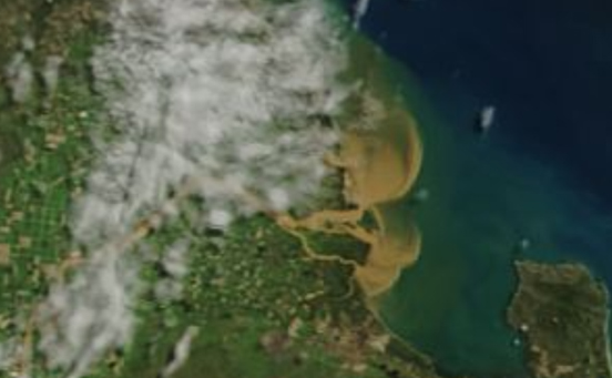
 High water levels in northern Queensland’s Wet Tropics region are subsiding after high rainfall in mid-March but the flood event may still have major impacts on the Great Barrier Reef.
Floodwaters send massive amounts of water laden with sediment from the north Queensland coastal plain out to the Great Barrier Reef lagoon, where it can cause serious problems for marine ecosystems.
Flood events are also major opportunities for scientists like Dr Aaron Davis and Dr Stephen Lewis from James Cook University, who are running water quality monitoring projects under the Tropical Water Quality Hub of the Australian Government’s National Environmental Science Program (NESP).
Dr Lewis, who is the principal researcher on NESP Tropical Water Quality Hub Project 2.1.5, said the section of the Great Barrier Reef off Townsville has so far avoided the majority of the flood plume, but wasn’t clear of the danger yet.
“Big floods are definitely important from a water quality researcher’s point of view,” he said.
“A plume like that is going to contain suspended sediment, including mineral sediment and organic material.

“We were taking sediment samples at Orchard Rocks near Magnetic Island, where we filtered over 15,000 litres of water and found the sediment in the water was very similar to what was leaving the mouth of the Burdekin.
“In these recent floods we had the strong south-easterlies which prevented those flood plumes, particularly the plume coming out from the Burdekin, from reaching the Great Barrier Reef mid-shelf region,” he said.
“If we’d seen northerlies during that period it’s likely we would have seen direct impact on mid-shelf reefs off Townsville. These impacts could have included a high chlorophyll content and sediment delivered out to the Reef, which reduce the amount of light reaching the coral.
“Our project is about tracking environmentally damaging sediment in the runoff, what we’re finding is that a fine sediment component moves hundreds of kilometres in these floods, eventually settles on the seafloor but doesn’t immediately compact into the substrate. So it forms this ‘fluffy’ layer on the seafloor that is much more easily re-disturbed by currents and wind action and dispersed back into the water column. It can go on to reduce light levels for both coral reefs and seagrass meadows for some time after the initial flood event.”
Dr Davis heads up NESP Tropical Water Quality Project 25, which involves accurately measuring water quality at multiple points along the Russell-Mulgrave catchment south of Cairns.
The aim of Project 25 is not just to determine the source of pollutants like dissolved inorganic nitrogen from agricultural activities and other industries along a catchment length, but to work closely with farmers to bring about impact recognition and practice change in the industry.
Dr Davis said the decisions and practices of farmers and other land users had significant effects on water quality levels.
“In terms of runoff and water quality impact it really depends on the timing of rainfall in relation to catchment activity. When you get a significant rainfall event in close proximity to major farming events like the application of fertilizer, that’s when we tend to see major water quality impacts” he said.
“These recent rains were quite a big events, there was a big catchment runoff, but it was months after most farmers have done their major applications. We’ll see soon if these rains have been a big player for the year on water quality.
“The engagement from farmers involved so far has been really great, I’m expecting some significant interest and thought about changes to farming practices from this, for at least the farmers involved in the program.”
The Tropical Water Quality Hub is the largest of the NESP research hubs, with approximately $32 million worth of projects dedicated to understanding and improving water quality issues affecting the Great Barrier Reef and other northern Australian marine ecosystems.
